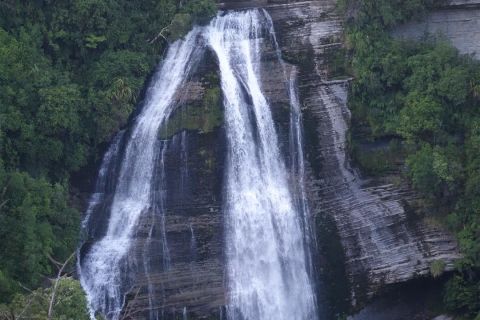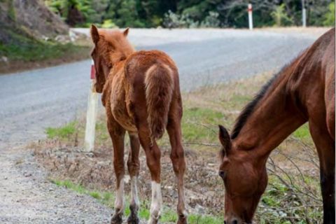
Photo credit: Jonathan Kennett.
Nature's Road (SH38) Heartland Cycle Trail
All information sourced from Ngā Haerenga New Zealand cycle trails website https://www.nzcycletrail.com/find-your-ride/heartland-rides/natures-road/
Te Urewera is a primeval forest prized for its ecological systems, biodiversity and cultural heritage. Notable outstanding natural features that cycle travellers will experience along the route include Lake Waikaremoana and Panekire Bluff.
Waikaremoana also features a New Zealand Great Walk hiking trail, with stunning natural beauty and longstanding appeal to visitors.
The route ascends from near sea level in the south-east to a maximum elevation of 930m, ascending and descending through mountain ranges before levelling out across the volcanic plateau in the central North Island.
The hill climbs are long, but the scenery is rewarding, and the magnificent forest canopy surrounding much of the route offers shelter from sun and wind. There are numerous bridged river crossings and spectacular waterfalls beside the route. Keep your eyes and ears open for the abundant wildlife.
Te Urewera is home to many species of native forest birds, and you are sure to meet horses along the way.
Trail detail
This route can be started from Frasertown or Murupara. Navigation is easy, as there is only one main road along the route.
Frasertown to Waikaremoana (Holiday Park): 55 km
Waikaremoana (Holiday Park) to Ruatāhuna: 47 km
Ruatāhuna to Murupara: 49 km
Photo credits: Mokau Falls - Jonathan Kennett. Nature's Road Horses - Te Uru Taumatua.
Need to know
CULTURE
Tūhoe are na Tamariki o te kohu, the children of the mist, the descendants of the mountains and the ever-present mist. Tūhoe origins lie in the land itself. The mountains, forests, lakes and river valleys of Te Urewera express and energise Tūhoe identity, opportunity and way of life.
Tūhoe’s association with the land for over 1000 years has created a rich heritage of ancestral connection, traditions, historic events, knowledge and stories that are of great interest to visitors wishing to deepen their own understanding and connection with the living system of Te Urewera.
ROAD CONDITIONS
The route follows a road that starts as a sealed highway, and then become a quiet gravel road, with sections that are surfaced using a pine sap. Traffic volumes start with several hundred vehicles a day and drop down to as low as 60 vehicles a day on average between Waikaremoana and Ruatāhuna.
FITNESS & SKILLS
This is a challenging and hilly grade 4 (advanced) ride on a mainly gravel road. It is suitable only for fit, experienced riders or those on e-bikes.
TYPE OF BIKE
As Nature’s Road consists of a lot of gravel, it is recommended to take a bike with wide tyres, such as a mountain bike or gravel bike.
If using an e-bike, riders will need to recharge their batteries at Waikaremoana and Ruatāhuna. The large hills will drain the battery faster than usual. Riders should have good mechanical skills and carry a tool kit.
MAPS & NAVIGATION
This trail follows the main road, and there are no significant turn-offs.
WEATHER
Te Urewera is well-known for its misty, and sometimes wet, weather. That is what helps the forest thrive. The ride is open year-round. Summer and autumn provide the best riding conditions, but it can rain at any time of year.
FOOD & ACCOMMODATION
Wairoa: Motel accommodation, supermarkets, restaurants, takeaways
Frasertown: Grocery store and takeaways
Tuai: Whakamarino Lodge offers accommodation and meals
Waikaremoana: Holiday Park has accommodation and a shop with basic supplies and hot food
Ruatāhuna: Te Tii offers chalet accommodation, café, grocery store
Murupara: Motel and campground, café, grocery store, takeaways.
In addition, there are BnB accommodation options at various points along the route.
GETTING THERE & AROUND
Many people ride from the Bay of Plenty to Te Urewera, via Motu Road, the Rere Falls Heartland Ride, and Tiniroto.
At Murupara you can catch a shuttle to Rotorua, 61 km away. Rotorua is a transport hub with an airport and an Intercity bus stop.
From Murupara, it is possible for experienced cyclists to ride up to Maunga Kākaramea/Rainbow Mountain, where the Te Ara Ahi Heartland Ride leads to Rotorua. That is a distance of 36 km.
However, the road is much busier, and has many logging trucks on it during weekdays. It is best to ride this section after 5pm on weekdays, or during the weekend.
Wairoa has an Intercity bus stop for connections to Napier or Gisborne, which both have airports and connections on to other places.
CELLPHONE COVERAGE
Mobile phone coverage is available at Murupara, Te Whaiti, and between Onepoto (Waikaremoana) and Frasertown.
There is public wifi available 24-7 at Te Kura Whenua, Waikaremoana.
There is public wifi available at Ruatāhuna during office hours.
However, there is no cellphone coverage between Te Whaiti and Onepoto (Waikaremoana).
It is recommended that cyclists with health issues carry a personal locator beacon through this area.
TOILETS
Public toilets are available in Wairoa, Tuai, Waikaremoana, Ruatāhuna and Murupara.
VISITOR INFORMATION
Te Urewera visitor information: https://www.ngaituhoe.iwi.nz/te-urewera
Waikaremoana visitor information: https://www.ngaituhoe.iwi.nz/lake-waikaremoana and Holiday Park bookings
Ruatāhuna visitor information and chalet bookings: https://tetiiruatahuna.com/
Wairoa visitor information: https://www.visitwairoa.co.nz/

